|
Map bolsters America-discovery claim
By Charlie Gidney (China Daily)
Updated: 2006-01-17 05:39
The controversial yet tantalizing theory that Chinese explorers may have
discovered America 70 years before Christopher Columbus gained credence
yesterday with a new map unveiled in Beijing.
The map is fairly small, only 60cm by 41cm, the oceans faded blue and the
continents crammed full of inscriptions and descriptions. In the bottom corner
is a couplet which says: "This chart is drawn by Mo Yi Tong, a subject of the
Qing Dynasty, in the year of Qianlong (1763), by imitating a world chart of 1418
(Ming Dynasty)."
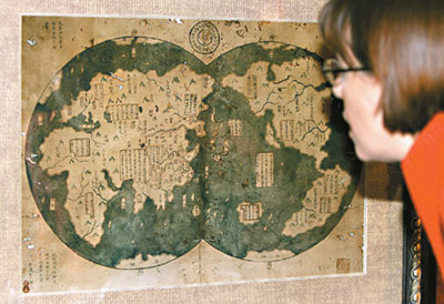
A journalist looks at a map which is said to
be an 18th century copy of the 1418 original, showing both North and South
America in unusual details, during a news conference in Beijing January
16, 2006. [Reuters] |
China is in the centre and dominates, but the shape and scale of Africa and
North America are impressive. California is mistaken as an island, Australia is
out of place and far too small, but other than that there are few significant
improvements in the European maps which immediately followed it.
The map is owned by Chinese lawyer and collector Liu Gang. He told China
Daily what caught his eye about the map: "When I saw its appearance, I could see
it wasn't contemporary. It must have been 1763 (because of the inscription),
imitating another map, but it had the outline of Antarctica. There was something
wrong, many descriptions and depictions were inconsistent with common knowledge
on world discovery, so I bought it. It was very cheap, only 4,000 yuan
(US$490)."
Liu purchased it in 2001, but only realized the potential importance when he
read "1421: The Year China Discovered The World," a divisive work by Gavin
Menzies, a retired British naval officer with a passion for maritime history,
published in 2003.
In his work, Menzies claims that Chinese explorers led by Zheng He
(1371-1433) discovered Australia, parts of Africa, the Americas, and even sailed
close to the Arctic. While historians bristled at the occasionally piecemeal
documentation and tenuous evidence, the book was a bestseller, and has been
praised for igniting academic debate into a previously unheralded topic.
In a telephone interview, Menzies told China Daily his feelings when he first
saw the map. "When I saw it, I didn't look carefully. I thought it was just a
sketch of a map that I had done!"
However, he has no doubts that the map is "absolutely, completely authentic."
"There are several reasons why. There are a number of European maps based on
this one, and they would also be forgeries if this were a fake. There is a mass
of corroborative evidence, and everything in the map appears in separate Chinese
records. Finally, European explorers found Chinese junks and evidence of Chinese
people in North America. This shows the Chinese were there first."
Historians from around the globe are studying the maps and evidence provided
by Menzies and Liu, but the map unveiled yesterday in the presence of virtually
the entire foreign press corps in Beijing including journalists from CNN, the
New York Times and the Finanacial Times certainly appears to be the most
convincing so far.
However, the fact that this map is only a reproduction of an early work, the
whereabouts of which is unknown, means the authenticity is unlikely to ever be
fully proved or disproved.
Aware that the map would likely come under immense scrutiny and questioning,
Liu said he strongly believed there were other similar maps out there, and he
hopes his decision to go public would help "wake up these maps."
The map also raises doubts over the dates of Zheng He's discovery of America,
which Menzies claimed was in 1421, but the map shows was prior to 1418. While
Liu was happy to put this detail down to a margin of error, Menzies was more
candid. "It is quite important. I have underestimated the extent of Zheng He's
voyages before 1421."
Liu has no doubt about its importance. He told China Daily: "In the view of
historians, Zheng He only sailed the Indian Ocean, but this map gives a
completely different picture. It will change Ming Dynasty (1368-1644) history,
and change the history of world discovery."
|